


1St. Brendan's Island
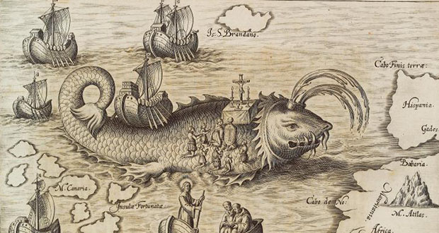
St. Brendan's Island is a fabled paradise island off the coast of Africa originating in 512 A.D., where Brendan claimed the sun never set. The island appeared in various maps and accounts for the next 1200 years.
2. The seafloor sonar data obtained during the underwater search for Flight 370 gave scientists an unusually-large section of deep-ocean seafloor mapped at high resolution. This data revealed numerous subsea volcanoes and evidence of large submarine landslides which were not previously known.
3. Kansas was selected as a common reference point for mapping because it was near the center of the contiguous United States. The latitudes and longitudes of every other point in North America were based on its direction, angle, and distance. Surveyors eventually benchmarked 250,000 stations.
4. It used to be the job of a ‘Road Scout’ to drive around the USA and constantly measure every road, grade, elevation, and distance and keep updating these road maps accurately every two weeks. They would drive enough miles in a year to make multiple trips to the moon.
5. Sandy Island near New Caledonia was a non-existent island which was included on many maps and nautical charts, including National Geographic Society and Google Maps. It showed up on maps in the late 19th century, until 2012 when a ship "undiscovered" it. It was removed from French hydrographic charts in 1974.
Latest FactRepublic Video:
15 Most Controversial & Costly Blunders in History
6Michelin Guide to France

The 1939 Michelin Guide to France was reprinted in 1944 for Allied military use, as its maps of the country were regarded as the best and most up-to-date of all available.
7. Belcher Islands are an archipelago in the southeast part of Hudson Bay, Canada. Before 1914, English-speaking cartographers knew very little about the Belcher Islands, which they showed on maps as specks, much smaller than their true extent.
8. During World War 2, the US Government officially wiped the town of Oak Ridge, Tennessee off the map, which was a town of 75,000 residents. They also made it a state secret plus inaccessible to help further the Manhattan Project and the development of the Atomic bombs.
9. A pulp and paper mill in Ontario was a Nazi POW camp during World War 2, and a captured navigator drew a map of the world by hand that is still there behind glass.
10. The National Transportation Noise Map is a very accurate color map of road and aviation noise in the United States.
11Hurricane Harvey Rain Map
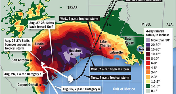
During Hurricane Harvey, the National Weather Service had to add two new colors to the rain accumulation map as the old color key topped out at an amount of rain they never before thought would fall.
12. Eratosthenes (276-194 B.C.) accomplished a lot of things during his lifetime. He was the first to accurately calculate and record the Earth's circumference, discover a method for finding prime numbers, explain the annual flooding of the Nile, coin the term "geography", and use longitude and latitude on a map.
13. Captain James Cook created the first proper map of Newfoundland. In the process, Cook renamed sites like Belleoram from Bande l'Arier and Bonne Bay from Baya Ederra. Named three sites after himself Cooks Cove, Cooks Brook, and Cooks Harbour. Finally, at Unfortunate Cove he injured his hand.
14. Before the military conflict with the United States in the 1840s, the map of Mexico included all or part of Texas, California, Nevada, Utah, Arizona, New Mexico, Colorado, and Wyoming.
15. The map of Normandy used to plan the D-day invasion was smuggled into Allied headquarters as a jigsaw puzzle. The pieces were then reassembled to form the map.
16Cessation of McDonald's, MO

The county of McDonald in Missouri tried to secede because they were left out of a tourist map in 1961. They created their 51st state in conjunction with at least 2 bordering counties and even had a mock war with local counties. The battle ended when a man got burned from an old musket blast.
17. The Mountains of Kong was a non-existent mountain range which was charted on the maps of Africa in the 19th century. It was believed to range from west to east Africa and connecting there with the also hypothetical Mountains of the Moon, just south of the Sahara.
18. The village of Winneconne, Wisconsin seceded from the state in 1967 when it accidentally went missing from the official state map. They tried to form a sovereign state or be annexed by another state before the governor met with them just one day after their proclamation.
19. French King Louis XIV commissioned the creations of "Plans-reliefs," which were 3D maps of towns, landscapes, and fortresses for planning military actions, starting in 1688. Hundreds were produced up until 1870 and many examples survive to this day in several museums in Paris.
20. The Book of Roger is a world atlas which was written by Arab geographer Muhammad al-Idrisi in 1154 for the Norman King Roger II of Sicily. It took him 15 years to make and was the most accurate world map for the next 300 years. The circumference of earth calculated in the book was off by less than 10%.
21Hy-Brasil

Hy-Brasil is a phantom island said to lie in the Atlantic Ocean west of Ireland. Irish myths described it as cloaked in mist except for one day every seven years when it becomes visible. It is listed on several early maps, but still cannot be reached.
22. The Copper Scroll is an ancient treasure map which was found among the Dead Sea Scrolls. It relates 64 positions where gold and silver have been hidden. Though searches are ongoing, as of yet, no treasure has been found.
23. The map used by the Flat Earth Society is a projection of the globe centered at the North Pole, called the 'Azimuthal equidistant projection.'
24. The origins of the Ordnance Survey maps lie in the aftermath of the 1745 Jacobite Rebellion, as maps of the Highlands were made to track down Jacobite dissenters and subjugate the clans.
25. There is an artificial archipelago of various small islands constructed in the rough shape of a world map, 4km (2.5mi) off the coast of Dubai. Named "The World," The islands are developed commercially and used as luxury resorts with hotels and beach clubs for corporate events and parties.


